NASA Coolness
They call it the Valley of the Gods.
You can suppose from my banner, and if you’ve been following this blog for a few years and know how often I go there on road trips, that Monument Valley is a recurring theme in my life. I spent the morning of my 50th birthday in the heart of Monument Valley, timing it just so I could be there, looking up at the stars, during the hour of my birth. If any physical place on earth could be said to be my spiritual center, the cathedral of my heart, it is there. I knew it the moment I first set foot in it back in 1974. It draws me to it in a way nothing else on earth does. The Navajo rightly regard it as sacred.
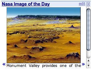
Wil Wheaton tipped his readers off on his blog recently, that a NASA "picture of the week" was a composite 3-D image of Monument Valley as seen from high overhead. According to the NASA site, it was "created by draping ASTER image data…over digital elevation data from the U.S. Geological Survey National Elevation Dataset." An experiment in planet rendering then. So here is planet Earth, in one of its surreal moods:
Click on the image to go to the NASA site and download the full resolution image.
It kinda blurs some of the features of the rock formations, taking the strangeness out of them (see my banner for a better view of one of the formations in this image). But in this composite you can better grasp the general way the area formed. As NASA says, it isn’t so much a valley as a low plain, the last remenants of a region of sandstone layers formed from massive sand dunes created at the edge of an inland sea millions of years ago. The dunes compressed over time into sandstone, which was later covered with several more layers of harder gravel and agates, and then the entire area was uplifted and volcanic activity covered it over yet again with an even harder layer of lava. It’s that hard rock over soft that creates the odd erosion shapes you see throughout the Valley. The whole thing has eroded over tens of thousands of years, leaving behind this vast desert space, framed by distant plateaus and rises, and punctuated by the most surreal buttes you have ever seen.
To get an appreciation of the massive forces involved in the region’s uplift, enter the valley from the north and the little town of Mexican Hat, so named for a huge balancing rock formation that looks just like an upside down Mexican hat perched on a tall pillar of stone. You can literally see these massive layers of rock all around you taking these sharp bends from horizontal to near verticle, as if they were clay in some giant’s hands.
In the NASA image you are looking somewhat to the south. The center of the Valley is in the foreground and you can almost make out the road that winds to Kayenta. The platau in the distance is the southern edge of the uplift zone. I think I can make out Church Rock there in the distance.
Somehow, I don’t know why exactly, this place is where my inner compass points.


